You can create up to 100 poligonal geofences inside Syrus devices
1. Open Google earth and create polygons of no more than 30 points each one. For this example, we are going to create Manhattan, Queens and Brooklyn geofences:
Manhattan

Brooklyn

Queens

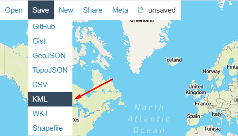
2. Create a folder containing the geofences and save it as a Kml file:

3.Open Syrus Desk -> Tools -> Lara Polygon COnverter

4, Specify paths for input and output file and click in “Convert”. This will generate a tmf file with all the TAIP commands


Now you can add these commands to a managed configuration, or send them via commands console or commands Interface in Pegasus